Skip to catalogue

June 21 — September 20

Toronto outdoors

Concierge

What are you in the mood for today?

Live search needs the app server. Browsing this city’s day below.

Checking concierge availability…

Your day in Toronto

26 ideas for Friday, July 24, 2026

24 fixed time0 places with confirmed hours1 with published schedule108 with flexible access0 with unknown time

133 Toronto activities · updated July 24, 2026 at 2:23 p.m.

Cabbagetown, Toronto
Flexible access
PlaceNeighbourhoods

Cabbagetown, Toronto

Cabbagetown is a neighbourhood in downtown Toronto, Ontario, Canada. Administratively, it is defined as part of the Cabbagetown-South St. James Town neighbourhood.

⌖ Cabbagetown, Toronto · Toronto
Practical information
Cost
From Wikipedia, the free encyclopedia

Sources checked Jul 18, 2026

Image: Wikimedia Commons

Chinatown, Toronto
Flexible access
PlaceNeighbourhoods

Chinatown, Toronto

Chinatown, Toronto (also known as Downtown Chinatown or West Chinatown) is a Chinese ethnic enclave located in the city's downtown core of Toronto, Ontario, Canada. It is centred at the intersection of Spadina Avenue and Dundas Street West.

⌖ Chinatown, Toronto · Toronto
Practical information
Cost
From Wikipedia, the free encyclopedia

Sources checked Jul 18, 2026

Image: Wikimedia Commons

East York
Flexible access
PlaceNeighbourhoods

East York

East York is a district and former municipality within Toronto, Ontario, Canada. From 1967 to 1998, it was officially the Borough of East York, a borough within the upper-tier municipality of Metropolitan Toronto.

⌖ East York · Toronto
Practical information
Cost
From Wikipedia, the free encyclopedia

Sources checked Jul 18, 2026

Image: Wikimedia Commons

Etobicoke
Flexible access
PlaceNeighbourhoods

Etobicoke

Etobicoke ( , eh-TOH-bik-oh) is an administrative district and former city within Toronto, Ontario, Canada.

⌖ Etobicoke · Toronto
Practical information
Cost
From Wikipedia, the free encyclopedia

Sources checked Jul 18, 2026

Image: Wikimedia Commons

Financial District, Toronto
Flexible access
PlaceNeighbourhoods

Financial District, Toronto

The Financial District is the central business district of downtown Toronto, Ontario, Canada. It was originally planned as New Town in 1796 as an extension of the Town of York (later the St. Lawrence Ward).

⌖ Financial District, Toronto · Toronto
Practical information
Cost
From Wikipedia, the free encyclopedia
Parking
Parking Authority

Sources checked Jul 18, 2026

Image: Wikimedia Commons

Forest Hill, Toronto
Flexible access
PlaceNeighbourhoods

Forest Hill, Toronto

Forest Hill is a neighbourhood and former village in Midtown Toronto, Ontario, Canada, located north of Downtown Toronto. The village was amalgamated into Toronto in 1967 and the area has retained its name as a neighbourhood.

⌖ Forest Hill, Toronto · Toronto
Practical information
Cost
From Wikipedia, the free encyclopedia

Sources checked Jul 18, 2026

Image: Wikimedia Commons

Greektown, Toronto
Flexible access
PlaceNeighbourhoods

Greektown, Toronto

Greektown, also known as The Danforth, is a commercial-residential neighbourhood and ethnic enclave in Toronto, Ontario, Canada. It is located on Danforth Avenue, between Chester Avenue and Dewhurst Boulevard, in east Toronto.

⌖ Greektown, Toronto · Toronto
Practical information
Cost
From Wikipedia, the free encyclopedia; were shot here, mentioned on free walking tours of the neighbourhood.

Sources checked Jul 18, 2026

Image: Wikimedia Commons

Kensington Market
Flexible access
PlaceNeighbourhoodsMarkets and shopping

Kensington Market

Kensington Market is a distinctive multicultural neighbourhood in Downtown Toronto, Ontario, Canada. The Market is an older neighbourhood and one of the city's best-known. In November 2006, it was designated a National Historic Site of Canada.

⌖ Kensington Market · Toronto
Practical information
Cost
From Wikipedia, the free encyclopedia; are sometimes seen handing out pamphlets at the corner of Baldwin and Kensington. Over the past two decades, several alternative bookstores have flourished in Kensington Market, including Who's Emma, the Anarchist Free Space, and Uprising Books.; The Pedestrian Sundays festival is a car-free festival where the streets close to cars in several Sundays in the summer. The festival ran for five years, attracting many people to party on the streets of Kensington
Parking
Narrow streets make the market challenging for those driving and especially parking in the neighbourhood. On Saturdays and some late afternoons, pedestrians walk freely down the middle of the street or between slow-moving cars. In the 2006 Canadian Census, 34.59% of Kensington residents walked to work, compared to 7.10% of City of Toronto residents. When considering the car, 15.70% of Kensington residents used a vehicle to get to work, whereas 49.39% City of Toronto residents drove a vehicle to

Sources checked Jul 18, 2026

Image: Wikimedia Commons
Leslieville
Flexible access
PlaceNeighbourhoods

Leslieville

Leslieville is a neighbourhood in Toronto, Ontario, Canada, situated east of the Don River. It is bounded by the Canadian National railway line and Gerrard Street to the north, McGee Street to the west, Eastern Avenue to south, and Coxwell Avenue to the east.

⌖ Leslieville · Toronto
Practical information
Cost
From Wikipedia, the free encyclopedia

Sources checked Jul 18, 2026

Image: Wikimedia Commons

Liberty Village
Flexible access
PlaceNeighbourhoods

Liberty Village

Liberty Village is a neighbourhood in Toronto, Ontario, Canada. It is bordered to the north by King Street West, to the west by Dufferin Street, to the south by the Gardiner Expressway, to the east by Strachan Avenue, and to the northeast by railway tracks.

⌖ Liberty Village · Toronto
Practical information
Cost
From Wikipedia, the free encyclopedia
Transportation
While preparing the Liberty Village Master Plan (2013), local residents were consulted on their general views and specific issues with the district. The responses were mixed. There were positive opinions expressed about Liberty Village's "sense of community", "youthful...[and] village atmosphere", and "sense of energy and vibrancy that comes from the concentration of creative sector businesses." Concerns were expressed about traffic congestion, the inadequacy and overcrowding of public transit,
Parking
wrote that "Liberty Village illustrates everything that's wrong with planning in Toronto," and that "civic propaganda would have us believe Liberty Village is a shining example of urban vitality". Hume described Liberty Village as "one huge parking lot after another", with very little green space.

Sources checked Jul 18, 2026

Image: Wikimedia Commons

Little Italy, Toronto
Flexible access
PlaceNeighbourhoods

Little Italy, Toronto

Little Italy, sometimes referred to as College Street West, is a district in Toronto, Ontario, Canada. It is known for its Italian Canadian restaurants and businesses. There is also a significant Latin-Canadian and Portuguese-Canadian community in the area.

⌖ Little Italy, Toronto · Toronto
Practical information
Cost
From Wikipedia, the free encyclopedia

Sources checked Jul 18, 2026

Image: Wikimedia Commons

Little Portugal, Toronto
Flexible access
PlaceNeighbourhoods

Little Portugal, Toronto

Little Portugal (also known as Portugal Village; Portuguese: Pequeno Portugal or, Aldeia Portugal) is a neighbourhood and ethnic enclave in Toronto, Ontario, Canada. It is located west of downtown in the "Old" City of Toronto.

⌖ Little Portugal, Toronto · Toronto
Practical information
Cost
From Wikipedia, the free encyclopedia

Sources checked Jul 18, 2026

Image: Wikimedia Commons

North York
Flexible access
PlaceNeighbourhoods

North York

North York is a former township and city and is now one of the six administrative districts of Toronto, Ontario, Canada. It is located in the northern area of Toronto, centred around Yonge Street, north of Ontario Highway 401.

⌖ North York · Toronto
Practical information
Cost
From Wikipedia, the free encyclopedia
Transportation
In addition to the TTC, other public transit services that may be accessed from North York include
Parking
is home to an office and a TTC commuter parking lot, which was sold for $25 million. A $300-million project is expected to create about 300 jobs and bring a new hotel, perhaps a four star Marriott, to the intersection.; "York Mills TTC parking lot slated for hotel, office complex"

Sources checked Jul 18, 2026

Image: Wikimedia Commons

Parkdale, Toronto
Flexible access
PlaceNeighbourhoods

Parkdale, Toronto

Parkdale is a neighbourhood and former village in Toronto, Ontario, Canada, west of downtown. The neighbourhood is bounded on the west by Roncesvalles Avenue; on the north by the CP Rail line where it crosses Queen Street and Dundas Street; on the east by Dufferin Street from Queen Street south; and on the south by Lake Ontario.

⌖ Parkdale, Toronto · Toronto
Practical information
Cost
From Wikipedia, the free encyclopedia

Sources checked Jul 18, 2026

Image: Wikimedia Commons

Queen Street (Toronto)
Flexible access
PlaceNeighbourhoodsMarkets and shopping

Queen Street (Toronto)

Queen Street is a major east–west thoroughfare in Toronto, Ontario, Canada. It extends from Roncesvalles Avenue and King Street in the west to Victoria Park Avenue in the east. Queen Street was the cartographic baseline for the original east–west avenues of Toronto's and York County's grid pattern of major roads.

⌖ Queen Street (Toronto) · Toronto
Practical information
Cost
From Wikipedia, the free encyclopedia
Transportation
Public transit; Toggle Public transit subsection
Parking
The commercial district of Queen Street East lies at the heart of The Beaches community. It is characterized by a large number of independent specialty stores. The stores along Queen are known to change tenants quite often causing the streetscape to change from year to year, sometimes drastically. East of Woodbine Avenue, Queen street has less traffic and is effectively reduced to one lane each way (the outer lanes are used for on-street parking). The centre lanes are used by the

Sources checked Jul 18, 2026

Image: Wikimedia Commons

Riverdale, Toronto
Flexible access
PlaceNeighbourhoods

Riverdale, Toronto

Riverdale is a large neighbourhood in Toronto, Ontario, Canada. It is bounded by the Don River Valley to the west, Danforth Avenue and Greektown to the north, Jones Avenue, the CN/GO tracks, Leslieville to the east, and Lake Shore Boulevard to the south.

⌖ Riverdale, Toronto · Toronto
Practical information
Cost
From Wikipedia, the free encyclopedia

Sources checked Jul 18, 2026

Image: Wikimedia Commons

Roncesvalles Avenue
Flexible access
PlaceNeighbourhoods

Roncesvalles Avenue

Roncesvalles Avenue is a north–south minor arterial street in Toronto, Ontario, Canada. It begins at the intersection of Queen Street West, King Street West and the Queensway running north to Dundas Street West.

⌖ Roncesvalles Avenue · Toronto
Practical information
Cost
From Wikipedia, the free encyclopedia
Parking
Roncesvalles Avenue has two centre traffic lanes carrying both road and streetcar traffic, 24/7 curb-side parking and bicycle lanes located between the on-street parking and the traffic lanes. At streetcar stops, the sidewalk is extended up to the streetcar tracks for easier boarding.; ". (Bumpouts are sidewalk extensions allowing passengers to board streetcars without stepping into the street.) The street's curb lanes were narrowed from 12–13 feet to 6.5 feet to become 24/7 parking lanes. Bicyc

Sources checked Jul 18, 2026

Image: Wikimedia Commons

Rosedale, Toronto
Flexible access
PlaceNeighbourhoods

Rosedale, Toronto

Rosedale is a neighbourhood in central Toronto, Ontario, Canada. It was formerly the estate of William Botsford Jarvis, and so named by his wife, granddaughter of William Dummer Powell, for the wild roses that grew there in abundance. It is located north of Downtown Toronto and is one of its oldest suburbs.

⌖ Rosedale, Toronto · Toronto
Practical information
Cost
From Wikipedia, the free encyclopedia

Sources checked Jul 18, 2026

Image: Wikimedia Commons

Scarborough, Ontario
Flexible access
PlaceNeighbourhoods

Scarborough, Ontario

Scarborough (; 2021 Census 623,610) is a district of Toronto, Ontario, Canada, situated in the eastern part of Toronto. Its borders are Victoria Park Avenue to the west, Steeles Avenue and the city of Markham to the north, Rouge River and the city of Pickering to the east, and Lake Ontario to the south.

⌖ Scarborough, Ontario · Toronto
Practical information
Cost
From Wikipedia, the free encyclopedia
Transportation
Public transit; into Scarborough, public transit connection between Scarborough and the rest of Toronto was limited and infrastructure investment from the municipal government and province of Ontario was low. In May 1988,

Sources checked Jul 18, 2026

Image: Wikimedia Commons

Swansea, Toronto
Flexible access
PlaceNeighbourhoods

Swansea, Toronto

Swansea is a neighbourhood in the city of Toronto, Ontario, Canada, bounded on the west by the Humber River, on the north by Bloor Street, on the east by High Park and on the south by Lake Ontario. The neighbourhood was originally a separate municipality, the Village of Swansea, which became part of Metropolitan Toronto in 1953.

⌖ Swansea, Toronto · Toronto
Practical information
Cost
From Wikipedia, the free encyclopedia
Transportation
. On Metro Council, she fought against amalgamation of Swansea into Toronto and in favour of spending for public transit over expressways.

Sources checked Jul 18, 2026

Image: Wikimedia Commons

The Beaches, Toronto
Flexible access
PlaceNeighbourhoods

The Beaches, Toronto

The Beaches (also known as "the Beach") is a neighbourhood in Toronto, Ontario, Canada. It is so named because of its four beaches situated on Lake Ontario. It is located east of downtown within the "Old" City of Toronto.

⌖ The Beaches, Toronto · Toronto
Practical information
Cost
From Wikipedia, the free encyclopedia

Sources checked Jul 18, 2026

Image: Wikimedia Commons

The Junction
Flexible access
PlaceNeighbourhoods

The Junction

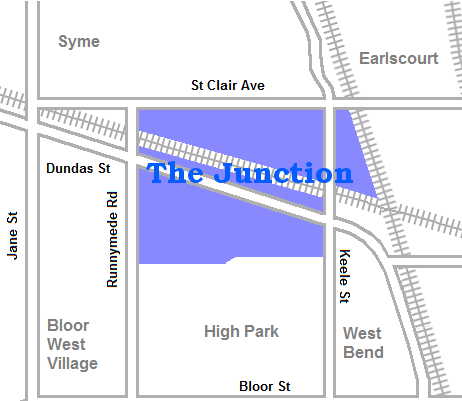
The Junction is a neighbourhood in Toronto, Ontario, Canada, that is near the West Toronto Diamond, a junction of four railway lines in the area. The neighbourhood was previously an independent city called West Toronto, that was also its own federal electoral district until amalgamating with the city of Toronto in 1909.

⌖ The Junction · Toronto
Practical information
Cost
From Wikipedia, the free encyclopedia

Sources checked Jul 18, 2026

Image: Wikimedia Commons

Toronto Eaton Centre
Flexible access
PlaceMarkets and shopping

Toronto Eaton Centre

The CF Toronto Eaton Centre, commonly referred to simply as the Eaton Centre, is a shopping mall and office complex in the downtown core of Toronto, Ontario, Canada. It is owned and managed by Cadillac Fairview (CF). It was named after the Eaton's department store chain that once anchored it before the chain went defunct in the late 1990s.

⌖ Toronto Eaton Centre · Toronto

Image: Wikimedia Commons

Wychwood Park
Flexible access
PlaceNeighbourhoods

Wychwood Park

Wychwood Park is a neighbourhood enclave and private community in Toronto, Ontario, Canada. It is located west of Bathurst Street on the north side of Davenport Road, within the larger area of Bracondale Hill. It is considered part of the overall Wychwood official neighbourhood as designated by the City of Toronto.

⌖ Wychwood Park · Toronto
Practical information
Cost
From Wikipedia, the free encyclopedia

Sources checked Jul 18, 2026

Image: Wikimedia Commons

Yorkdale Shopping Centre
Flexible access
PlaceMarkets and shopping

Yorkdale Shopping Centre

Yorkdale Shopping Centre is a shopping mall in Toronto, Ontario, Canada, at the southwest corner of the Highway 401 and Allen Road interchange in the former city of North York.

⌖ Yorkdale Shopping Centre · Toronto
Practical information
Cost
From Wikipedia, the free encyclopedia
Transportation
Public transit
Parking
4 parking lots; statue was relocated from the base of the CN Tower to the west parking lot of Yorkdale in 1994.; statue in the west parking lot was relocated from the base of the; , sufficient for 40 storefronts, and 800 underground parking spaces.; This new wing took the space of the southwest parking lot. The expansion also relocated and doubled the number of seats at the; . The new parking garage was built below the wing.; store. This project involved the closure of the Rainforest Café (at Yo

Sources checked Jul 18, 2026

Image: Wikimedia Commons

Yorkville, Toronto
Flexible access
PlaceNeighbourhoodsMarkets and shopping

Yorkville, Toronto

Yorkville is a neighbourhood and former village in Toronto, Ontario, Canada. It is roughly bounded by Bloor Street to the south, Davenport Road to the north, Yonge Street to the east and Avenue Road to the west, and it is part of The Annex neighbourhood. Established as a separate community in 1830, it was annexed into Toronto in 1883.

⌖ Yorkville, Toronto · Toronto
Practical information
Cost
From Wikipedia, the free encyclopedia

Sources checked Jul 18, 2026

Image: Wikimedia Commons